Geo Information
Geographical Information System
Until 1992, the Survey department produced and supplied topographic data exclusively in the form of printed maps and plans using conventional mapping techniques. With the advent and development of computers, information technology, data storage capacities and database management systems, a new method was emerged in the world to store information in a computer is named as Geographic Information System (GIS). GIS is a computer system designed to capture, store, manipulate, analyze, manage and present all types of georeferenced geographic data.
The department entered the mainstream of developments in computer assisted technology for mapping in 1992 at photogrammetric branch for data collection. The GIS branch was established in 1999 and started with commenced of digitizing printed 1:50000 & 1:10000 scale topographic maps in order to create the digital topographic database. Then the existing digital data of 1:10000 were converted into GIS format with different layers. With these data, the Survey Department has established digital topographic vector databases for GIS applications which can be supplied for the users. The digital topographic vector databases comprise of eight different data layers that vary slightly depending on the scale. The data file contains eight different layers of point, line & polygon geometry including administrative boundaries, buildings, transport, hydrology, terrain, land use, toponomy & utility.
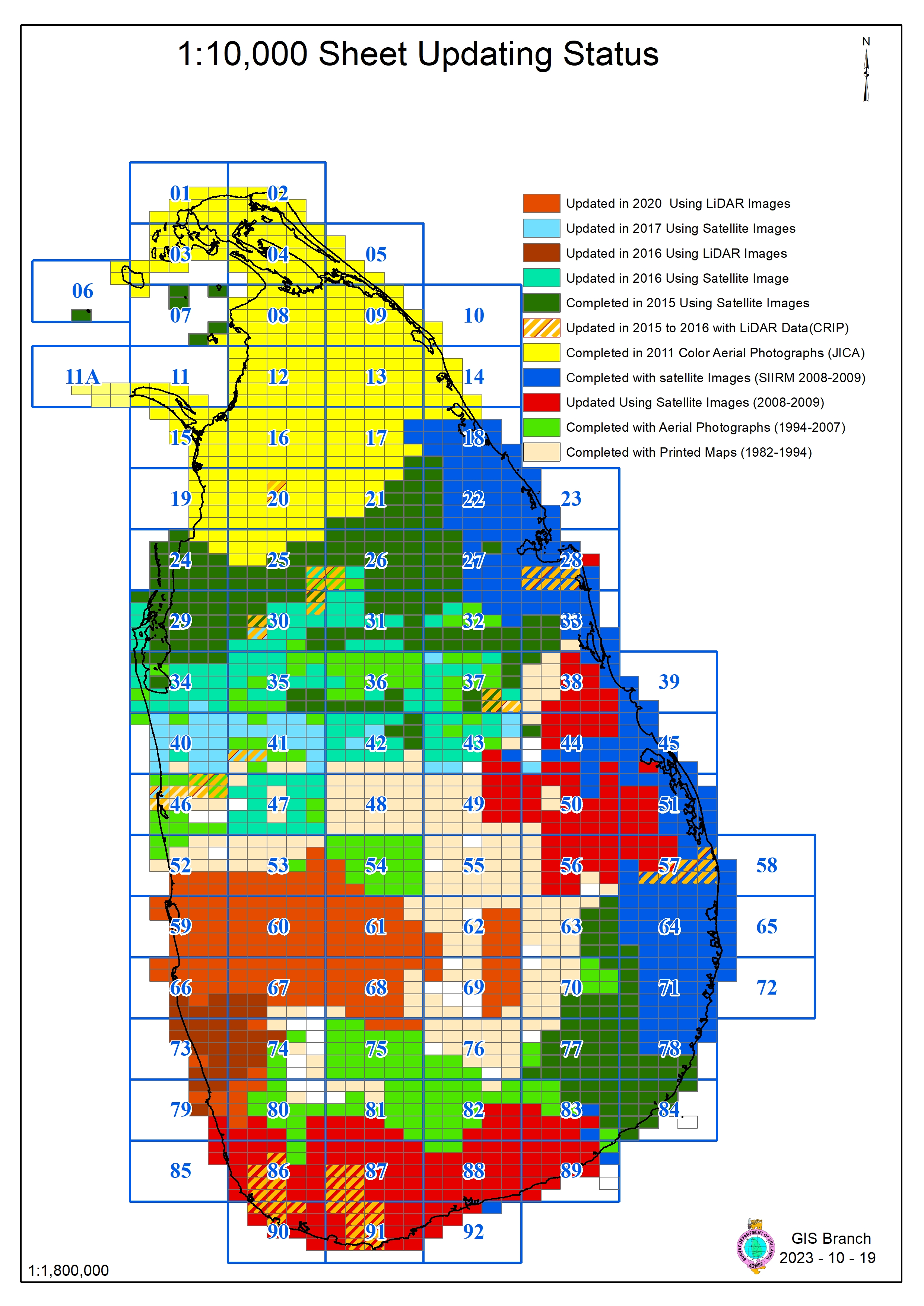
The databases are in GIS format and organized in the form of tiles as shown in the grid index for topographic mapping. The data can be supplied either as separate tiles in the form of original data format, or as shape files or as DXF files. Our digital topographic data is available for use in GIS applications, in the scales which reflect their level of accuracy and best scale for use.
Main functions performed by geographical Information System branch
-
Creation and maintenance of 1: 10000 topographic databases.
-
Creation and maintenance of 1: 1000 topographic databases in the area of Colombo and suburb and other special areas.
-
Preparation of nationally or locally important GIS data on request.
-
Preparation of miscellaneous type GIS Data on request.
-
Development of GIS applications including web GIS application.
-
Creation and maintenance of thematic databases.
-
Providing data required for the production of maps to the Senior Superintendent of Surveys (Mapping).
-
Handling GIS related activities based on user demand.
Below are some of the special work that has been done recently by this branch
-
Mapping the GN boundaries of 339 DS divisions for delimitation
-
Create kml file by entering District, DS and GN data in all 25 districts
-
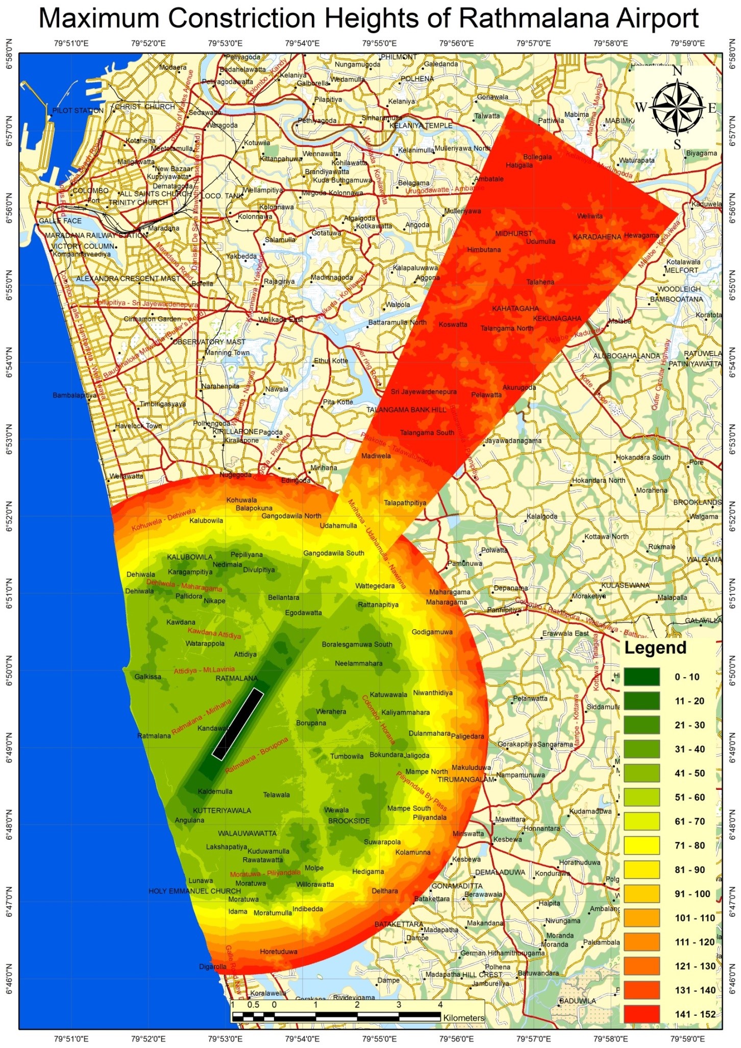
Creating a DSM to restrict the construction of buildings around the airport so that their height does not interfere with flight.
-
Currently a school database and a hospital database are created by this Branch and their applications are being developed
23 data layers in the completed database. Those are
-
Ad_Boundary_Li - Boundaries of Grama Niladhari Division, Divisional Secretariat,District & Province
-
Ad_Ds_Pg - Divisional Secretariat Area
-
Ad_District_Pg - District Area
-
Ad_Gn_Pg - Grama Niladhari Division Area
-
Ad_Province_Pg - Province Area
-
Ca_Tile_Pg - Full Sheet Area of The Data Set
-
Ca_Toponym_Pt - Various Data Including This Layer. Those are Estate Name, Miscellaneous Point, Place Name, Town Name, Village Name, Trig Points, Housing Scheme, Island Name & Historical Site
-
Co_Building_Pg - Including Agency Post Office, Air Port, Bank Building, Hospitals –Base & Building -Unspecified Buildings etc. Shown as Polygon
-
Clouds - Shown Obscure Area on Data Source
-
Hy_Hydro_Li - All Hydro Features Shown as Line
-
Hy_Hydro_Pg - All Hydro Features Shown as Polygon
-
Hy_Hydro_Pt - Including Culvert, Tube Well, Well, Spring & Water Tower Shown as Point
-
Lu_Landuse_Pg - Including various Land Use type as Polygon
-
Lu_Landuse_Pt - Used for Labelling Land Area
-
Lu_Landuse_Li - Land area which are Not Covered by Hydro &Transport Line
-
Lu_Reserve_Pg - Forest &Wildlife Reserves
-
Te_Terrain_Li - Terrain Line
-
Te_Terrain_Pt - Spot Height
-
Tr_Transport_Li - All Transport Line
-
Tr_Transport_Pt - Junction Name, Kilometer Post Etc.
-
Ut_Utility_Li - Including Penstock Line, Water Tunnel, Water Pipe Line, Power Transmission Line, Electric Wire Fence &Power House/ Grid Stations Shown as Line
-
Ut_Utility_Pt - Transformer, Telecommunication Tower, Tower (High tension) & Wind Turbine Shown as Point
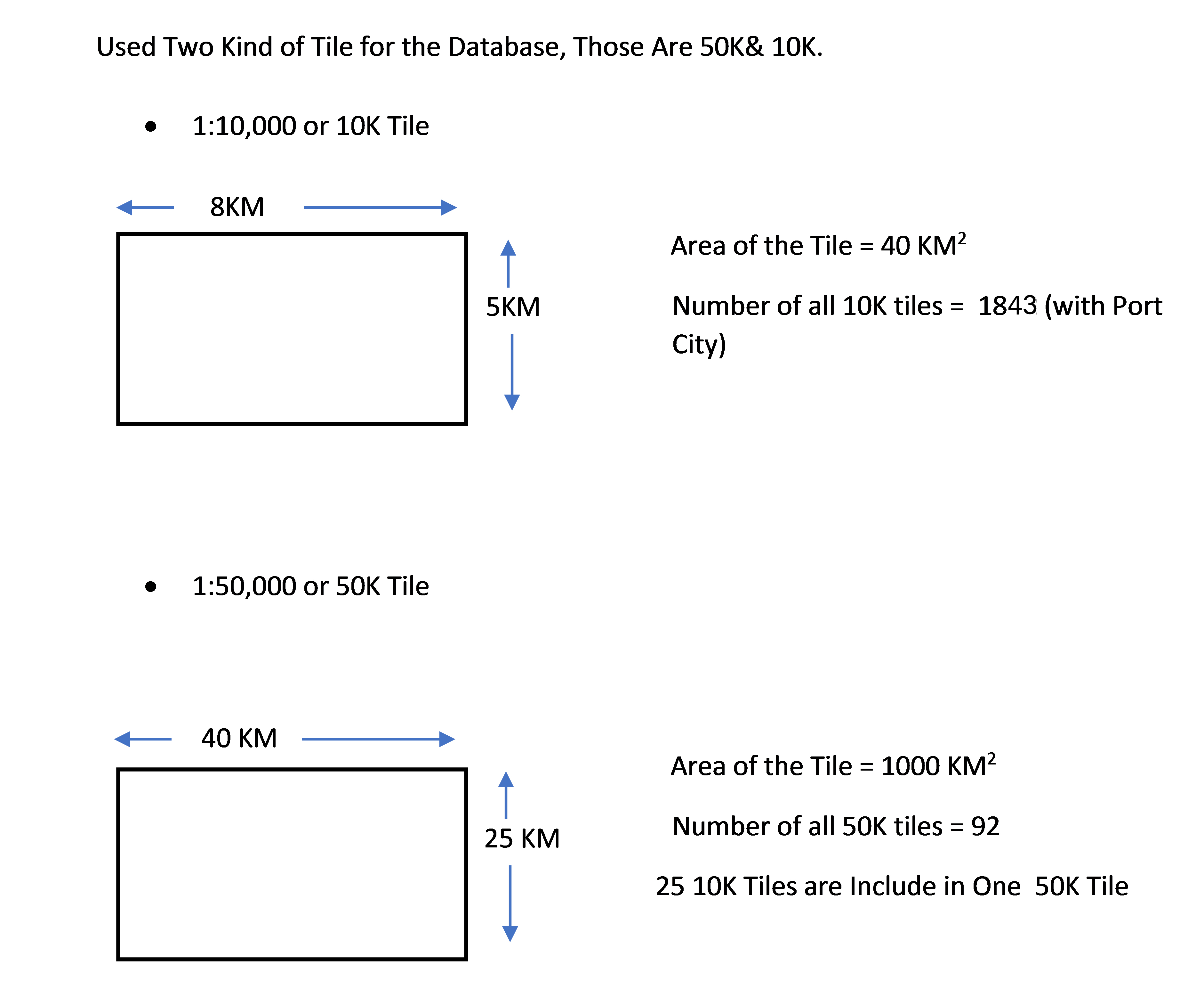
Two main scales are used for this database, 50K and 10K.
Various Data sources are have used for capturing data. Those are
-
Printed Map
-
By Ground Survey (Coverage)
-
By Manual Sketching (Coverage)
-
Aerial Photograph
-
Satellite Images (Geodatabase)
-
Ortho Photo from LiDAR Survey