Welcome Message
W. Sudath L.C. Perera
SURVEYOR GENERAL
SURVEY DEPARTMENT OF SRI LANKA
Distinguished Delegates and Guests,
Your warm welcome to remote sensing and spatial information sciences enthusiasts attending the 2024
Asian Conference on Remote Sensing (ACRS 2024) is greatly appreciated. It's wonderful to hear that the
ACRS is jointly hosted by the Sri Lanka Survey Department (SLSD) and the Asian Association on Remote
Sensing (AARS), making it a significant international conference in Asia.
Hosting the conference in Colombo, Sri Lanka, is a testament to the country's commitment to the field
of remote sensing and its contributions to the ACRS. With a history of hosting ACRS since 2008, it's clear
that Sri Lanka is dedicated to providing a fruitful symposium and extending its warm hospitality to all
participants. Such conferences play a vital role in advancing knowledge, fostering collaboration, and
addressing important global challenges through remote sensing and spatial information sciences.
As a leading Government Organization in Remote Sensing and geosciences in Sri Lanka, SLSD has long
been an active partner in the associated communities. With a history of 223 years and a strong
reputation, SLSD has undoubtedly made substantial contributions to these domains. Hosting the ACRS
2024 conference in Sri Lanka is an excellent opportunity to showcase the country's achievements and
capabilities in these fields. I'm sure the attendees will benefit from the symposium program and enjoy
their stay in Sri Lanka.
Prof.Kohei Cho
GENERAL SECRETARY
ASIAN ASSOCIATION ON REMOTE SENSING (AARS)
Dear International Colleagues,
It is our great pleasure to organize the 45th Asian Conference on Remote Sensing (ACRS) from 17th to 21st November 2024 in Colombo, Sri Lanka. Last year, we organized the 44th ACRS in Taipei with 815 participants from 44 countries and regions. This year, we, the Asian Association on Remote Sensing (AARS) and the Local Organizing Committee (LOC) of Sri Lanka, are co-organizing the conference. This is our fifth time to organize ACRS in Sri Lanka. The first time in 1983, 2nd in 1996, 3rd in 2008, and 4th in 2016. This means that Sri Lanka is one of the key players in AARS.
Many of us still remember the successful ACRS organized in Colombo in 2016.
I visited Colombo this August and discussed with LOC on the preparation for the Conference. I was quite impressed with the good planning and teamwork of the LOC Chaired by Mr. W. Sudath L.C. Perera, Surveyor General of the Survey Department. I was pleased to know that more than 400 people had already registered for the conference. Various topics on remote sensing, including image processing, GIS, Big Data, Small Satellites, AI, and various applications, will be presented and discussed during the conference. I have no doubt about the success of the Conference. Looking forward to seeing you all at ACRS2024 in Colombo.
Latest News
Scope of Asian Conference on Remote Sensing (ACRS)
Realizing the importance of Remote sensing technology in
national development
activities, Asian countries have formed an association on remote sensing in Asia to
discuss share and developed expertise in the field of Geo information handling and
management all over the world. Membership of Asian Association on Remote
Sensing (AARS) is limited to Asia and near Asian countries in which Sri Lanka is
founder member. Survey Department of which is National Mapping organization
also functions as a national Centre for Remote sensing in Sri Lanka and an
Ordinary member of AARS.
Read more >>
previously held in Sri Lanka in 1983, 1996, 2008 and 2016. The Asian countries/ regions which are expected to participate in this conference are: Australia, Azerbaijan, Bangladesh, Brunei, China, India, Iran, Japan, Malaysia, Mongolia, Nepal Pakistan, Philippines, Thailand, Vietnam, Taiwan and Sri Lanka. France, the Netherlands, Switzerland, UK, USA and the United Nations ESCAP representative. Approximately 300 foreign participants and the 200 local participants attend the conference which is held annually in one of Asian countries. The last conference of ACRS held in Sri Lanka was in the year 2016. Duration of the conference is 5 days from Monday to Friday. Hosting the ACRS in Sri Lanka will benefit the country immensely in promoting Remote Sensing activities in Sri Lanka and also attract International and national attention which in no doubt would Flourish tourism in Sri Lanka.
Keynote Speakers

Prof. Dr. Jiang Jie
Secretary General, ISPRS
Beijing University of Civil Engineering and
Architecture
China
Spatial-temporal Information Technology Supports the Protection of Architectural Heritage.
Prof. Dr. JIANG Jie received her BSc. and MSc. degrees in Applied Geophysics from the Changchun University of Geology, China, and PhD in Surveying Engineering from China University of Mining and Technology (Beijing). She worked as a remote sensing and GIS specialist in the Municipal Urban Planning and Management Information Center of Changzhou during 1989 to 1999, as a senior engineer in the National Geomatics Center of China during 2000 to 2018. Since October 2018, she serves as full professor in School of Geomatics and Urban Spatial Informatics, Beijing University of Civil Engineering and Architecture. She took in charge of several national-level projects on remote sensing and GIS applications, among them the most important ones included the National Platform for Geoinformation Services, Mapping with Chinese Satellite Images, the National Geodatabases for E-government, and the National Databases for In-car Navigation. Her recent research focuses on spatial-temporal modelling for smart city. She has served the International Society for Photogrammetry and Remote Sensing (ISPRS, www.isprs.org ) since 1998. She is now ISPRS Fellow, and the Secretary General of ISPRS (for term 2022-2026). She got the ISPRS President’s Citations, ISPRS The Eduard Dolezal Award. She published more than 100 papers, got the National Science and Technology Progress Award of China, and more than 10 Ministry level Awards.

Mr. S. Sivanantharajah
Former Surveyor General
Survey Department of Sri Lanka
Sustainable Land Administration System (LAS) for National Development.
Mr.S.Sivanantharajah received his B.Sc First Class Honours from University of Peradeniya in 1985 and Higher Diploma in Surveying and Mapping with Second Class honors from ISM, Diyatalawa, in 1991. While working in the Survey Department he has completed the M.Sc in Geoinformatics from ITC, The Netherlands, in 2000.
He worked in the Survey Department of Sri Lanka for last 35 years including 31 years in the head office branches in multiple disciplines such as Computer, Land Information System (LIS), Centre for Remote Sensing (CRS), Geographic Information System (GIS) & Map Publications and 4 years in the field duties. He has been the 53rd Surveyor General.
He served as part-time visiting lecturer to M.Sc in GIS & Remote Sensing at the University of Peradeniya & University of Sri Jayawardanepura on Remote Sensing (RS) & Geographic Information System (GIS). He has good working experience in GIS & RS software’s mainly ArcView/ArcGIS/ArcGIS Pro and ERDAS for last 25 Years.

Dr. Fabio Remondino
Senior researcher
Head of Research Unit
Bruno Kessler Foundation (FBK)
Trento,
Italy
Integrated and Complementary Approaches in Photogrammetry and Remote Sensing.
Fabio received a PhD in Photogrammetry from ETH Zurich in 2006 and he is now the head of the 3D Optical Metrology research unit at FBK - Bruno Kessler Foundation, a public research center located in Trento, Italy. His main research interests are in the field of reality-based surveying and 3D modeling, sensor and data fusion and 3D data classification. He is working in all automation aspects of the entire 3D reconstruction pipeline for applications in the industrial, environmental and heritage fields. He is the author of more than 250 articles in journals and conferences. He is involved in knowledge and technology transfer, organizing more than 30 conferences, 20 summer schools and 5 tutorials. He has received 10 best paper awards at international conferences, beside the D.C. Brown award, the ISPRS President's Honorary Citation and the E.H. Thomson award. Fabio was serving as President of the ISPRS Technical Commission II (2016-2020) and V (2012-2016), Vice-President of EuroSDR (2017-2023) and vice-President of CIPA Heritage Documentation (2015-2019).

Prof. Jagannath Aryal
Associate Professor
University of Melbourne
Victoria
Earth Observation Data and Intelligent Methods for Disaster Management: Supporting Resilience.
Originally from Nepal, Dr Jagannath Aryal was trained and educated as a Geomatics Engineer in different parts of the world. He received his PhD degree in Optimization and Systems Modeling followed by his Professional Master in Geoinformatics (University of Twente, The Netherlands) and Master of Surveying (University of Otago, New Zealand). He is currently an Associate Professor in the Department of Infrastructure Engineering at the University of Melbourne, Australia. He leads a research group on Earth Observation and AI. Professionally, he leads the GIS, Digital Analytics and Remote Sensing, area of practice of the Geospatial Council of Australia, the peak professional body representing the geospatial sector as a national chair. He is the program director of the Master of Digital Infrastructure Engineering and Graduate Certificate Degrees at the University of Melbourne. He currently serves to the global Remote Sensing community as a leading academic and an Associate Editor of IEEE Transactions on Geoscience and Remote Sensing (TGRS) journal. His research focuses on optimal utilization of Earth Observation, geo- information, and geo-statistics to develop new methods in object recognition and geospatial situational awareness in disaster and emergency situations. Objects of interest derived from sensing technology (Ground / Satellite based) are applied in modeling and mapping various environmental systems taking sustainability and resilience into account.
Plenary Session Speakers

Dr. Shailesh Nayak
Director
National Institute of Advanced Studies
Indian Institute of
Science Campus
Bengaluru
Towards Sustainable Blue Economy: Role of Remote Sensing.
Dr. Shailesh Nayak is currently the Director, National Institute of Advanced Studies, Bengaluru, Chancellor, TERI School of Advanced Studies, New Delhi, and Editor-in-Chief, Journal of the Indian Society of Remote Sensing, Dehradun. He obtained his PhD degree in Geology from the M.S University of Baroda in 1980. He was Secretary, Ministry of Earth Sciences, during 2007-2015 and provided leadership for programs related to earth system sciences. His current research interest includes building strategy for blue economy, sustainable development and promoting research in the Indian Ocean and polar regions. He had set up the state-of-the-art tsunami warning system for the Indian Ocean in 2007 and provided tsunami advisories to the Indian Ocean rim countries. He has pioneered the development of algorithms and methodologies for the application of remote sensing to the coastal and marine environment, and generated the baseline database of the Indian coast, and developed services for fishery and ocean state forecast. This coastal database has formed basis for managing the Indian coast. He was instrumental in creating database of the glaciers of the Indian Himalaya. He is an Academician of the International Academy of Astronautics (IAA) Fellow of the International Society of Photogrammetry & Remote Sensing (ISPRS) and Indian National Science Academies. He is Regional Representative for Asia at the ISPRS Council. He was conferred the prestigious ISC Vikram Sarabhai Memorial Award 2012 and Bhaskara Award for 2009, for his outstanding contributions in Remote Sensing and GIS. He has published about 190 papers in peer- reviewed journals. The Government of India awarded the Civilian Honor ‘Padma Shri’ in recognition of his outstanding contributions in the field on Science and Engineering.
Your space available here
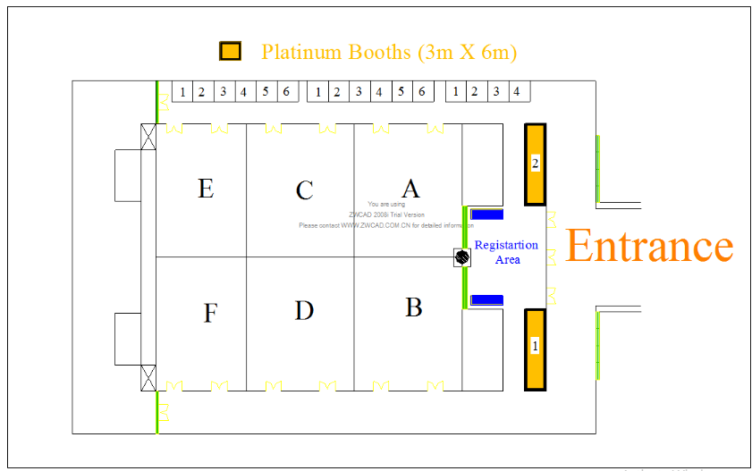
Platinum
Sponsor
Price
$30,000
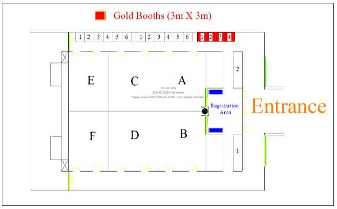
Gold
Sponsor
Price:
$12,000
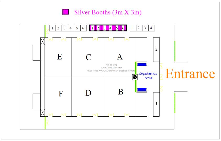
Silver
Sponsor
Price:
$10,000
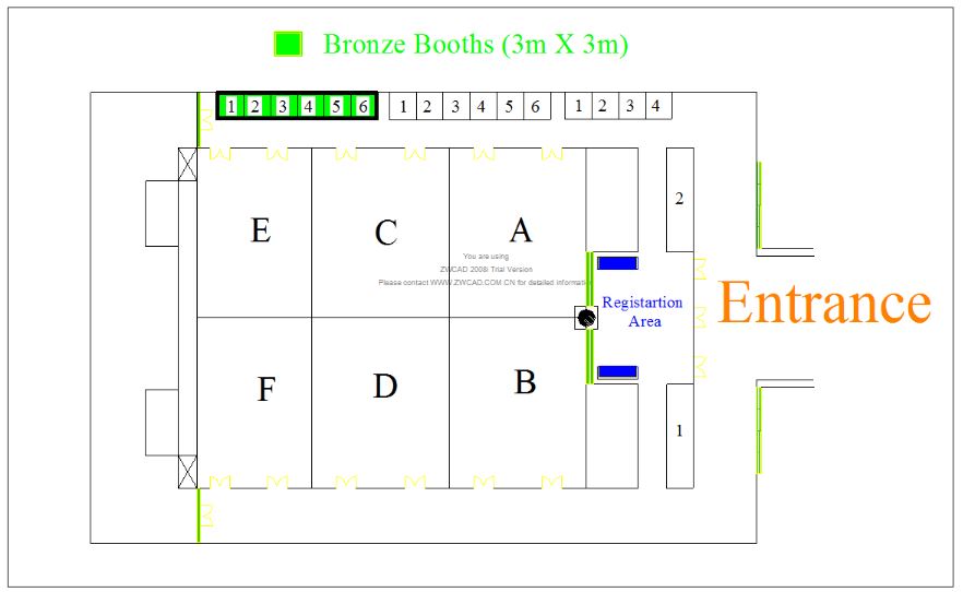
Bronze
Sponsor
Price:
$8,000
Exhibitors
Sponsor
Price:
$2,500
Special
Sponsor
For Locally Registered Companies
Silver Sponsor
Special Sponsor
Main Organizer
Asian Association on Remote Sensing
Survey Department of
Sri Lanka
Ministry of Tourism & Lands,
Government of Sri Lanka
Get in touch
W. Sudath L.C. Perera
SURVEYOR GENERAL
Contact Information
Surveyor General's Office, No 150, Bernad Soysa Road, Narahenpita, Colombo 05, Srilanka
Venue


