Land Information
Survey Plans & Diagrams
Land survey is performed in order to locate and preparation of plan / map of the boundaries and corners of a parcel of land. It might also include the topography of the parcel, and the location of buildings and other improvements made to the parcel.
This land survey information is an important requirement for land development projects and land use planning activities. An extensive range of current and historical survey documents are available in the Survey Department in variety of formats. Most of the documents are available to the general public and have been facilitated by the Survey Department.
Survey Plans
Survey plan is the graphical representation to some scale, of the features on, near or below the surface of the earth as projected on a horizontal plane which is represented by plane of the paper on which the plan is drawn.
Different types of plans have been produced by the Survey Department by time to time and some of them are as per the following.
Title Plans (TP)
Title plans were the first type of plans produced by the Survey Department after establishment in 1800. Specially, these plans are prepared to sell the lands to private sector in Dutch – British period and different types of Title Plans had been prepared during the period of 1800 – 19….
Copies of Title Plans are issued to the public from Document Management and Professional Standards (DM & PS) branch in Surveyor General‘s Office (Head Office) or from District Survey office.
-
Title Plans without any prefix (1,2,3,…)
-
Title Plans with Prefix 'T ' ( T1,T2,T3, …)
-
Crown Title Plans (Cr.T.P. 1, Cr.T.P. 2, …)
-
Vesting Order Title Plans
-
Temple Title Plans
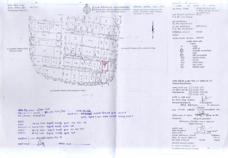
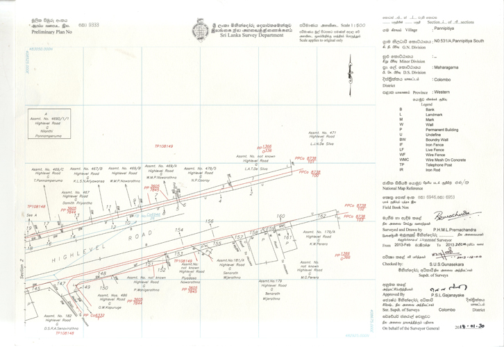
Preliminary Plans (PP)
At the beginning, individual Title Plans were prepared for each required land parcel by surveying of each land parcel separately and later, instead of preparation individual plans for each and every land parcel, one single plan was prepared by surveying all the land parcels adjacent to each other. This type was named as Preliminary Plans.
With the introduction of the Waste Land Ordinance to the country preparation of preliminary plans were restricted to urban areas where the state lands are limited.
-
Preliminary Plans without any prefix (PP).
-
Preliminary Plans with prefix "A" (PPA).
-
Preliminary Plans with prefix "S" (PPS).
-
Preliminary Plans with prefix for each district.
-
Chena Survey Preliminary Plan (Chena PP).
-
Miscellaneous Survey Preliminary Plan (MSPP).
-
Irrigation Survey Preliminary Plans (ISPP…).
-
Forest Survey Preliminary Plans(FSPP…).
-
Town Survey Preliminary Plans (TSPP).
Plans under Settlement
Due to the limited extent of state lands are available in urban areas, Priority was given to survey and prepare plans in rural areas under the Waste Land Ordinance.
While all the land parcels in a selected village have been surveyed and following types of plans under settlement were prepared but state and private lands shown on the plans are not settled. State and private lands are settled and final settlement order was issued by the Land Settlement Department.
-
Block Survey Preliminary Plans (BSPP).
-
Block Survey Village Plans (BSVP).
-
Topographical Preliminary plans (Topo. PP).
Finally Settled Plans
Upon receipt of final settlement order from Land Settlement Department , a final settled plan is prepared by the Survey Department for that particular village/villages accordingly.
There are several types of plans are available in the Survey Department related to above.
-
Final Village Plans (FVP)
-
Finally Topographical Plans (FTP)
-
Final Settled Plan (FSP)
-
Final Colony Plan (FCP )
-
Final Urban Plans( FUP)
Survey Diagrams
Generally followings are the survey diagrams prepared by the Survey Department as per the requirement for issue of grant, lease, vesting, ., etc, for lands and attached with.
-
L - Lease Diagrams - Attached to Lease Bond.
-
O - Outright Grant Diagrams - Attached to Outright Grant.
-
V - Vesting Order Diagrams - Attached to Vesting Order Certificate.
-
S - Settlement Order Diagrams - Attached to Settlement Order.
-
R - Restricted Grant Diagrams - Attached to Grant under the Land Development Ordinance.
-
M – Mining Right Diagrams - Attached to Deeds of Assignment of Mining Rights.